

OPCIONES DE ENTREGA LOCAL
La entrega estándar suele tardar entre 3 y 7 días.La entrega urgente suele tardar entre 2 y 4 días.
GARANTÍA DE PRECIO
Si encuentras un precio más barato en las próximas 72 horas lo igualaremos.
Original price was: 291,66 €.262,49 €Current price is: 262,49 €.
You save
10 in stock
La entrega estándar suele tardar entre 3 y 7 días.La entrega urgente suele tardar entre 2 y 4 días.
Si encuentras un precio más barato en las próximas 72 horas lo igualaremos.
Consigue un descuento inicial del 5% en tu primer pedido registrándote en la comunidad SailRACE.
Obtenga asistencia de expertos con certificación oficial. Detállenos sus necesidades de reacondicionamiento y le ayudaremos a determinar la mejor solución.
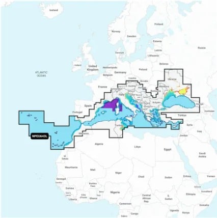
A comprehensive, all-in-one solution, Navionics+ charts and maps combine clear, reliable coastal/inland content with advanced guidance features and compatibility with a wide range of chartplotter brands.
Navigate with our best offshore and inland lake coverage for your compatible chartplotter.
See it your way. Customize your view with various chart layers and overlay combinations.
With your included 1-year subscription, access daily updates via the Navionics® chart installer software.
Advanced route guidance technology lets you navigate with suggested dock-to-dock routings.
Selectable map options let you highlight shallow areas, adjust contour density or select a fishing range.
Save money — while continuing to access daily updates plus new content downloads — by renewing your subscription.
Access detail-rich mapping of coastal features, lakes, rivers and more on a wide range of compatible chartplotters. Integrated coastal and inland lake content offers coverage for boaters worldwide.
Charts are constantly being enhanced with new and amended content — thousands of updates are made every day. The included 1-year subscription gives you access to daily chart updates via the Navionics chart installer software.
Advanced route guidance technology uses your boat settings, along with chart data and frequently traveled routes, to calculate a suggested path to follow from dock to dock.
For improved fishing and navigation, up to 1′ contours provide a clear depiction of bottom structure for fishing charts as well as enhanced detail in swamps, canals, harbors, marinas and more.
Change the way you view Navionics charts to focus on the details that matter most to you. Highlight shallow areas, adjust contour density, or select a fishing range.
Download community edits for useful local knowledge added by users of the Navionics Boating app, and view the data on your compatible chartplotter.
Transfer routes and markers, update charts and more between your plotter card and mobile app — wirelessly. You can even activate or renew your cartography subscription and upload sonar logs.
Create your own maps on the fly. Watch new 1’ HD bathymetry maps develop in real time as your boat moves through the water.
This downloadable shading feature combines color and shadow to give you an easy-to-interpret, clearer view of bottom structure than contour lines alone.
The downloadable sonar imagery feature reveals bottom hardness clearly and in contrasting color, highlighting both subtle and dramatic transition areas on select U.S. lakes.
Downloadable high-resolution satellite imagery provides a realistic view of your surroundings — ideal for entering unfamiliar harbors or ports.
Crystal-clear aerial and surface photos of ports, marinas, bridges, docks, boat ramps, dams and navigational landmarks provide a better sense of your surroundings above the waterline.
Unique 3D views provide additional perspective, both above and below the water’s surface, to highlight key features and aid in situational awareness.
Los siguientes productos son de la misma categoría que éste:


Navionics+™ de Garmin
Navionics Platinum+™ | NPEU010R | Spain, Mediterranean Coast – Marine Charts

Navionics+™ de Garmin
Garmin Navionics+™| Aegean Sea, Sea of Marmara – Marine Charts


10 in stock

Reseñas
Aún no hay comentarios