

LOCAL DELIVERY OPTIONS
Standard Delivery usually 3-7 days.Express Delivery usually 2-4 days.
PRICE GUARANTEE
If you find a cheaper price in the next 72 hours we will match it.


Original price was: 2.428,93 €.2.113,17 €Current price is: 2.113,17 €.
You save
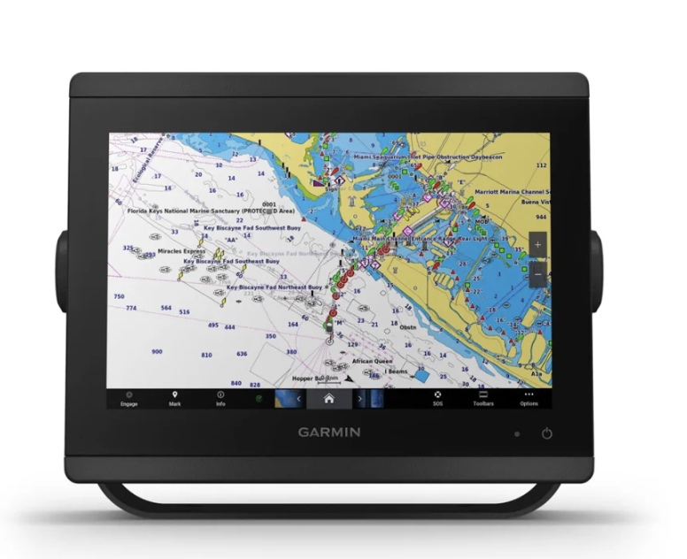
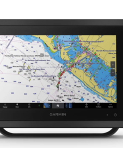
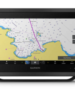
SERIOUS SAILORS, SAILORS AND SAILERS NEED A PROFESSIONAL TEAM
The combination of plotter and probe, easy to use and install, has multifunction display (MFD) technology in a small set.
Standard Delivery usually 3-7 days.Express Delivery usually 2-4 days.
If you find a cheaper price in the next 72 hours we will match it.
Claim your initial 5% discount on your first order by registering on the SailRACE community.
Get support by officially certified experts. Detail us your refitting needs and we will help you determining the best solution.
SERIOUS SAILORS, SAILORS AND SAILERS NEED A PROFESSIONAL TEAM
The combination of plotter and probe, easy to use and install, has multifunction display (MFD) technology in a small set.
IPS HD TOUCH SCREEN
This screen, available in 10′′, 12′′ or 16′′, offers wider viewing angles and greater clarity and readability to sunlight, even with polarized sunglasses.
SIMPLE AND ATTRACTIVE ASSEMBLY OPTIONS
You can install several screens, whether flush-mounted or without edges to achieve an elegant look of a glass control bridge or recessed mount to create an imposing look.
REMOTE CONTROL FOR GHC™ 20
The simple optional GRID 20 remote entry device provides remote and intuitive access and control of the entire Garmin nautical system.
COMPATIBILITY WITH TRADITIONAL AND EXPLORATION PROBES
Enjoy integrated compatibility with traditional 1 kW dual-channel CHIRP probe for superior separation of the lenses and ClearVü and SideVü exploration probes to see up to 300 m (1000 feet) below and around the boat at 260 kHz (the transducer is sold separately). Support for integrated probe is only available on xsv models.
PANOPTIX PROBE COMPATIBILITY™
Link your plotter with Panoptix or Panoptix LiveScope™, an easy-to-interpret live probe (the transducer is sold separately), to see what surrounds the boat in real time.
NAVIGATION FUNCTIONS GARMIN SAILASSIST™
Visualize functions such as laylines, race start line, improved wind rose, course and path lines on land, real wind data fields and slider of tides, currents and weather, wind angle, direction and drift, wind speed and many others.
MAPS AND MAPS
Renew your plotter with the optional Garmin Navionics+™ mapping or the advanced Garmin Navionics Vision+™, which includes built-in coastal and indoor content, access to daily updates, Auto Guidance+™2 technology and much more.
VELA POLARS
Use the polar table to consult key data, such as the speed at which you must go with a certain angle and wind speed. So you will know if you need to modify the setting of the candles.
RED GARMIN
If you have several Garmin devices on your boat, you can share the information (such as maps, user data, radar and IP cameras) with each other.
NMEA 2000® AND NMEA 0183 NETWORKS
Access automatic pilots, digital switching, weather forecast, your FUSION-Link™ audio system, multimedia content, VHF, AIS and much more on a single screen.
ACTIVECAPTAIN® APPLICATION
Integrated Wi-Fi® connectivity that allows the link to the free all-in-one application to access the OneChart™ function, smart notifications3, software updates, Helm, Garmin Quickdraw™ community data and much more.
INTEGRATED BLUETOOTH® AND ANT TECHNOLOGIES
Connect with some of your favorite devices, such as quatix® nautical watches, gWind™ Wireless 2 transducers, GNX™ Wind nautical instruments and wireless remote controls.
ONEHELM FUNCTION™
This function brings together all the operations and functions of third-party devices, such as EmpiriBus™ digital switching, on a single screen.
SMARTMODE STATION CONTROLS
Quickly and with a single touch, access the necessary information and facilitate stressful situations, such as mooring. You can incorporate probes, radars, cameras, supports and much more on the network.
POWER-POLE® ANCHOR FOR SHALLOW AREAS
By connecting certain Garmin plotters with a Force® electric motor and a compatible Power-Pole shallow anchoring system, you can access advanced boat control functions6 from the plotter, such as intelligent anchor automatic deployment, intelligent anchor displacement, automatic retraction, clutch detection and anchoring at the end of the route when navigating with Auto Guidance2. You spend more time fishing and less positioning yourself.
CHARGING INTEGRATION FROM POWER-POLE
Your Power-Pole CHARGE nautical power manager integrates with compatible Garmin plotters to give you more battery life and power in the water. It allows you to charge batteries on the go, monitor energy consumption, select where energy is allocated, control emergency starts and even transfer energy between batteries, all from the plotter screen.
SEND MESSAGES USING INREACH® DEVICES
Link your inReach5 satellite communication device to the plotter and write personalized messages using the MFD on-screen keyboard. Access your contact list or enter an email, an inReach address or a phone number. You can also group messages by conversation to enjoy an experience similar to that of text messages.
| Screen size (Width/High) | 21.8 cm x 13.7 cm; 10.1″ (25.7 cm) diagonal |
| Power input | 10-32 Vdc |
| Screen resolution (Width/High) | WUXGA; 1920 x 1200 px |
| GPS | Yes |
| Dimensions of the unit (Width/High/Depth) | 25,9 cm x 20,5 cm x 7,5 cm |
| Receptor | GPS/GLONASS/Galileo de 10 Hz |
| Classification of water resistance | IPX7 |
| Weight | 2,4 kg |
| Assembly options | On the surface, flush or recessed. (Garmin does not provide any mounting component or accessory for a flush installation. Professional knowledge and tools are required). |
| Type of screen | IPS touch screen (anti-glare finish) |
| Garmin Navionics Vision+™ | Yes |
| Supports data cards | 2 SD™ cards (on the back of the unit) |
| Rutas | 100 (250 waypoints per unit) |
| Garmin Navionics+™ | Yes |
| Waypoints | 5,000 |
| Navigation functions | Yes |
| Compatible with NMEA 0183 | Yes |
| Built-in receiver | Yes |
| USB ports | Yes |
| TOPO 100K | Yes |
| SideVü | Yes (with GCV™ black box, sold separately) |
| Amite DSC (sends the position data to the VHF compatible with DSC) | Yes |
| Touch screen | Yes |
| LakeVü g3 Ultra | Yes |
| Compatible with NMEA 2000® | Yes |
| ActiveCaptain-yhteensopiva | Yes |
| Typical current consumption at 12 V DC | 1.5 A |
| NMEA 2000® Ports | 1 |
| Tide prediction | Yes |
| GLONASS | Yes |
| Track points | 50,000 |
| Panoptix™ sonar | Yes |
| Garmin Marine Network ports™ | 2 |
| LakeVü g3 | Yes |
| Compatible with WAAS | Yes |
| GSD™ Black Box -luotaimen tuki | Yes |
| Maximum current consumption at 12 V DC | 6.0 A |
| Compatible with Garmin SmartMode (customizable monitor default settings) | Yes |
| Auto ruta | No |
| Maximum electricity consumption at 10 V DC | 40.1W |
| BlueChart g3 | Yes |
| Standard maps | Yes |
| LakeVü (interior) | No |
| Show the probe | Yes |
| ANT+™ (Connectivity) | Yes |
| GCV™ Black Box -luotaimen tuki | Yes |
| BNC port for external antenna | No |
| Entrance ports NMEA 0183 | 1 differential |
| Voice audio alerts | Yes |
| BlueChart g3 Vision | Yes |
| Garmin Wi-Fi® network (local connection) | Yes |
| J1939 ports | 1 |
| Screen keys | No |
| Garmin Quickdraw Contours | Yes |
| Bluetooth® calls | Yes |
| Supports AIS (tracks the position of the target boats) | Yes |
| Video output ports – None | 1 HDMI |
| Compatibility with raster cards | Yes |
| Puertos de entrada (Tx) NMEA 0183 | 1 |
| Compatibility with OneHelm™ | Yes |
| ClearVü | Yes (with GCV™ black box, sold separately) |
| Tracks | 50 saved tracks |
| Wireless control | Yes |
| Admite radios compatibles con FUSION-Link™ | Yes |
| Galileo | Yes |
| LiveScope | Yes |
| BlueChart® (coast) | No |
| Traditional probe (dual beam/frequency) | Yes (with GCV™ black box, sold separately) |
| Compatible with GRID™ (Garmin remote input device) | Yes |
| Video input ports | 1 BNC composite video
1 HDMI (compatible with HDCP) |
| Brand |
|---|
The following products are from the same Category as this one:


Garmin

Garmin


Reviews
There are no reviews yet